Luxembourg sandstone
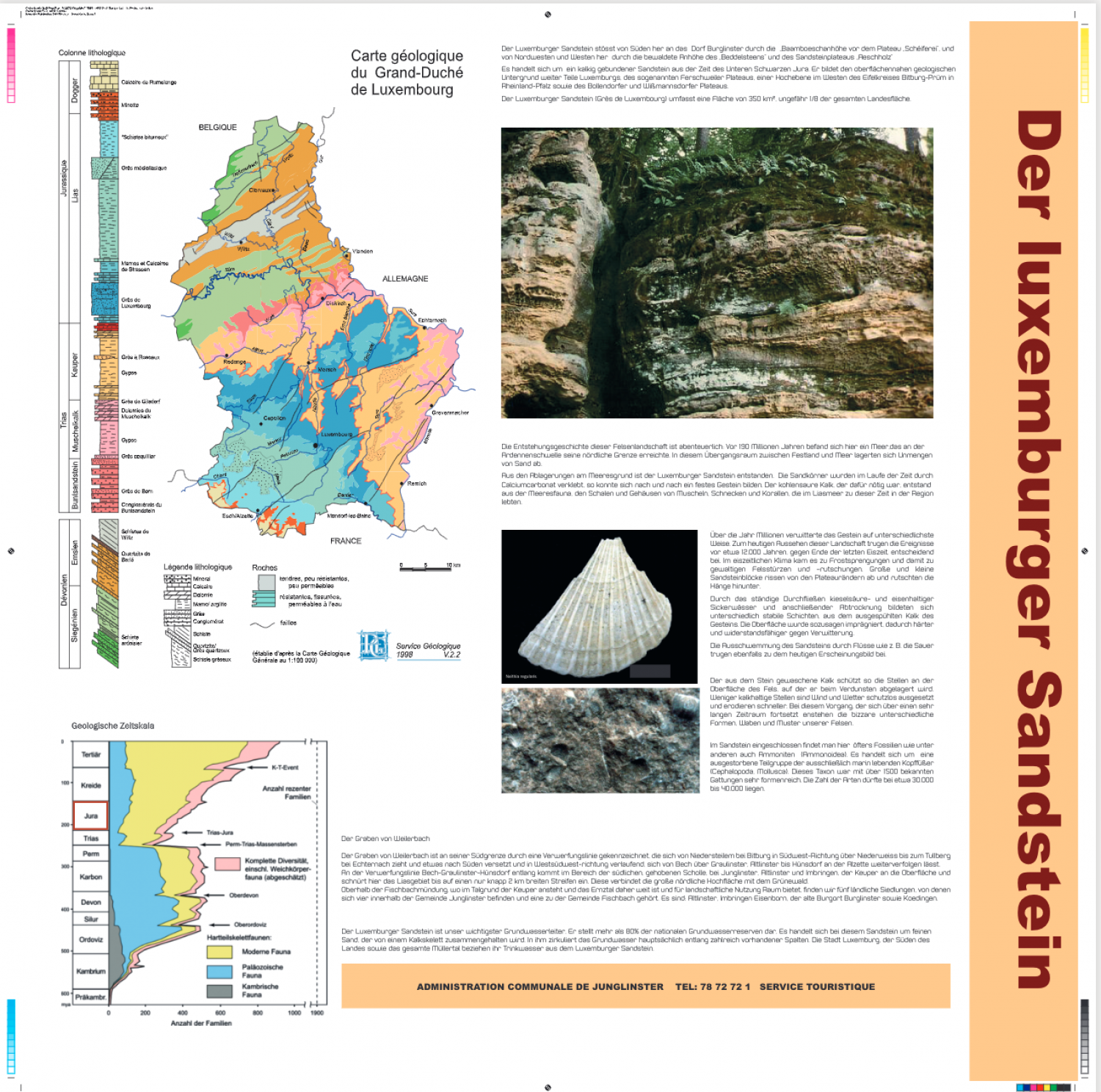
The Luxembourg sandstone runs up against the village of Burglinster from the south via the “Baamboaeschan Heights” in front of the “Schéiferei” plateau, and from the northwest and west via the wooded heights of the “Beddelsteen” and the sandstone plateau “Aeschholz”. This is a siliciously cemented sandstone dates from the Lower Black Jurassic era. It forms the geologic foundation just under the surface of large portions of Luxembourg – the so-called Ferschweiler Plateau, a high plain to the west of the Eifelkreis Bitburg-Prüm in Rheinland-Pfalz and the Bollendorf and Wissmannsdorf Plateaus. The Luxembourg sandstone (Grès de Luxembourg) covers an area of 350 km2, around 1/8 of the total land area. This boulder landscape has an adventurous history: 190 million years ago, this was an ocean, the northern-most boundary of which was the threshold of the Ardennes. In this transitional area between sea and solid ground, enormous quantities of sand collected. Luxembourg’s sandstone developed from this sediment on the ocean floor. Over time, the grains of sand became cemented together with calcium carbonate, slowly building up solid stone. The necessary calcium carbonate arose from the ocean fauna – the shells and housing of muscles, snails and corals which lived in this region of the Lias Sea at that time. Over millions of years, the stone weathered in various ways. The events of around 12,000 years ago, around the end of the last ice age, were decisive for the appearance of the landscape today. Frost wedging occurred in the icy climate, resulting in the collapse of cliffs and violent landslides. Sandstone blocks of all sizes broke off of the edges of the plateaus and slid down the slopes. Due to the constant flow of silicic acid and iron-containing seepage water, followed by periods of drying, layers of varying stability were built up from the lime rinsed from the stone. The surface was impregnated, so to speak, making it harder and more resistant to weathering. The washing out of the sandstone by rivers such as the Sauer also contributed to the look of the land today. The lime washed from the stone protects the surface of the boulders where it was deposited due to evaporation. Some lime-free areas were exposed unprotected to the wind and weather, thereby eroding more quickly. Due to this process, continued for a very long time, the wide array of bizarre shapes, honeycombs and patterns emerged. Encased in the sandstone, one often finds fossils, such as ammonites (ammonoidae). These are an extinct subspecies of cephalopod which lives exclusively in water (cephalopoda, mollusca). This taxon was widely varied with more than 1,500 known genera. The number of species is likely between 30,000 and 40,000. The Trench of Weilerbach The Trench of Weilerbach is defined on its southern boundary by a fault line which runs from Niedersteilem near Bitburg towards the southwest via Niederweiss, all the way to Tulberg near Echternach. Somewhat further south, it can be followed further in a west-southwesterly direction from Bech via Graulinster and Altlinster to Hünsdorf at Alzette. Along the fault line Bech-Graulinster-Hünsdorf, the Keuper comes to the surface in the area of the southern raised plate near Junglinster, Altlinster and Imbringen, and constricts the Lias region down to a strip of land about 2 km wide. This connects the great northern heights with the Grünewald. Near the river mouth at Fischbach, where the Keuper is present in in the valley floor and the Ernz valley is therefore very broad and offers space for agricultural uses, we find five rural settlements within the parish of Junglinster and one which belongs to the parish of Fischbach. These are Altlinster, Imbringen, Eisenborn, the old castle town of Burglinster and Koedingen.
Download Flyer (PDF)